Quick Answer: How High is Everest Base Camp?
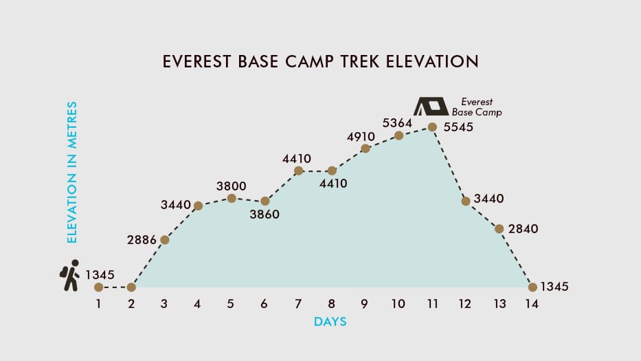
- South Everest Base Camp (Nepal): 5,364 meters / 17,598 feet above sea level on the moving Khumbu Glacier.
- North Everest Base Camp (Tibet / China): 5,150 meters / 16,900 feet above sea level on the Rongbuk Glacier.
- Highest Point Reached on the EBC Trek: Kala Patthar at 5,644 meters / 18,519 feet (the iconic landmark summit above Gorak Shep).
- Mount Everest Summit: 8,848.86 meters / 29,031.7 feet (official Nepal–China joint elevation).
- Oxygen Availability at EBC: Approximately 53% of sea level oxygen availability due to lower barometric pressure (53.0 kPa vs. 101.3 kPa at sea level).
Everest Base Camp height in Nepal is officially 5,364 meters (17,598 feet) above sea level. When people ask, “How high is Everest Base Camp?”, they are almost always referring to South Base Camp situated at the foot of the Khumbu Icefall in Nepal’s Sagarmatha National Park. While this is not the 8,848.86m summit of Mount Everest, trekking and sleeping at this altitude pushes human physiology into the “Very High Altitude” medical category.
At 5,364 meters, the atmospheric pressure drops by nearly half compared to sea level. Every breath delivers approximately 47% fewer oxygen molecules into your bloodstream, making ordinary actions like tying boot laces, walking a slight incline, or digesting a hearty meal feel substantially harder. Understanding the exact elevation profile, pressure changes, and pacing protocols is what separates a comfortable trek from an emergency evacuation.
Everest Base Camp Elevation: Key Altitude Benchmarks
| Location / Landmark | Altitude (Meters) | Altitude (Feet) | Significance |
|---|---|---|---|
| Kathmandu | 1,400 m | 4,593 ft | Nepal’s capital city; start of international travel |
| Lukla Airport (Tenzing-Hillary) | 2,860 m | 9,383 ft | Mountain flight landing strip; official trailhead |
| Namche Bazaar | 3,440 m | 11,286 ft | Sherpa capital; first mandatory acclimatization stop |
| Tengboche Monastery | 3,867 m | 12,687 ft | Spiritual heart of the Khumbu with Ama Dablam panorama |
| Dingboche | 4,410 m | 14,469 ft | Second mandatory acclimatization hub; tree line ends |
| Lobuche | 4,940 m | 16,207 ft | High alpine settlement alongside the Khumbu moraine |
| Gorak Shep | 5,164 m | 16,942 ft | Highest teahouse settlement; staging post for EBC |
| Everest Base Camp (South, Nepal) | 5,364 m | 17,598 ft | Main trek destination on the Khumbu Glacier |
| Kala Patthar Viewpoint | 5,644 m | 18,519 ft | Highest point on the classic EBC trek route |
| Everest Summit | 8,848.86 m | 29,031.7 ft | Highest point on Earth (official 2020 measurement) |
Why Breathing Feels Harder: Barometric Pressure & Oxygen Levels
A common misconception is that the percentage of oxygen in the air decreases at high altitude. In reality, the air composition remains steady at roughly 20.9% oxygen from sea level all the way to the summit of Everest. What actually changes dramatically is barometric (atmospheric) pressure.
15-Day Everest Base Camp Trek
Guided Himalayan journey to Everest Base Camp (5,364m). Includes permits, teahouse lodging, all trekking meals, local Sherpa guide, porters, and Lukla flights.
As you ascend, the weight of the atmosphere pressing down decreases. Because the air pressure is lower, air molecules—including oxygen—are spread further apart (lower partial pressure of oxygen, \(pO_2\)). With every lungful of air you inhale at Everest Base Camp, you take in roughly half the oxygen molecules you would at sea level.
| Location | Altitude | Barometric Pressure | Effective Oxygen Availability |
|---|---|---|---|
| Sea Level | 0 m (0 ft) | 101.3 kPa (760 mmHg) | 100% (Baseline) |
| Lukla | 2,860 m (9,383 ft) | 72.0 kPa (540 mmHg) | ~72% |
| Namche Bazaar | 3,440 m (11,286 ft) | 67.5 kPa (506 mmHg) | ~67% |
| Dingboche | 4,410 m (14,469 ft) | 59.8 kPa (448 mmHg) | ~60% |
| Everest Base Camp | 5,364 m (17,598 ft) | 53.0 kPa (398 mmHg) | ~53% |
| Kala Patthar | 5,644 m (18,519 ft) | 51.2 kPa (384 mmHg) | ~50% |
| Death Zone Threshold | 8,000 m (26,247 ft) | 38.0 kPa (285 mmHg) | ~37% |
| Everest Summit | 8,848.86 m (29,031.7 ft) | 33.7 kPa (253 mmHg) | ~33% |
South Base Camp (Nepal) vs. North Base Camp (Tibet): Altitude Comparison
Mount Everest straddles the international border between Nepal and the Tibet Autonomous Region of China. Consequently, there are two distinct Everest Base Camps:
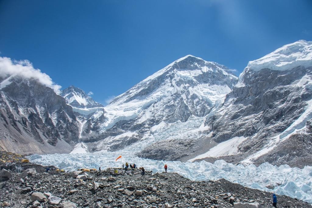
- South Everest Base Camp (Nepal): 5,364 meters / 17,598 feet. Reached via a multi-day foot trek through the Khumbu Valley. It sits directly on the active, shifting ice of the Khumbu Glacier beneath the steep Khumbu Icefall. No roads reach South Base Camp.
- North Everest Base Camp (Tibet): 5,150 meters / 16,900 feet. Located on the northern side of Everest on the Rongbuk Glacier. Unlike Nepal’s side, North Base Camp is accessible via a paved road from Lhasa and Shigatse with electric tourist shuttles, meaning visitors can drive directly to near the camp without trekking.
Because the Nepal South Base Camp is 214 meters (702 feet) higher and requires walking over 130 km round-trip, the physical conditioning, acclimatization schedule, and gear requirements for Nepal are vastly more rigorous than visiting the Tibet side.
Everest Base Camp vs. Kala Patthar: Which Is Higher?
Many first-time trekkers assume that Everest Base Camp is the highest point of the trek. However, Kala Patthar (5,644 meters / 18,519 feet) is 280 meters (921 feet) higher than Everest Base Camp.
Furthermore, you cannot actually see the peak of Mount Everest from Everest Base Camp itself. At Base Camp, the massive western shoulder of Nuptse and the Everest West Ridge block the summit from view. Kala Patthar—a black rocky ridge directly above Gorak Shep—provides the famous, unobstructed 360-degree panorama of Everest’s south face, Lhotse, Nuptse, and the entire Khumbu Icefall.
| Feature | Everest Base Camp | Kala Patthar |
|---|---|---|
| Exact Height | 5,364 m / 17,598 ft | 5,644 m / 18,519 ft (+280m higher) |
| View of Everest Summit | Hidden by Nuptse ridge | Full panoramic view of peak & South Col |
| Terrain | Glacial moraine, ice, loose rocks | Steep dirt path, switchbacks, granite summit rocks |
| Time from Gorak Shep | 2.5 to 3.5 hours (one-way) | 1.5 to 2.5 hours (steep uphill climb) |
| Typical Visit Time | Afternoon of Day 11 | Early morning sunrise of Day 12 |
How Far Is Base Camp From the Summit of Everest?
Trekkers standing at Base Camp often look up at the mountain and wonder: “How far is it from here to the very top?”
- Vertical Altitude Gain: 3,484.86 meters (11,433.7 feet). From 5,364m at Base Camp to 8,848.86m at the peak.
- Horizontal Climbing Distance: Approximately 20.5 kilometers (12.7 miles) along the standard South Col route.
- Climbing Stages: Base Camp (5,364m) → Camp 1 (6,065m via Khumbu Icefall) → Camp 2 (6,400m in Western Cwm) → Camp 3 (7,162m on Lhotse Face) → Camp 4 / South Col (7,920m in the Death Zone) → Hillary Step & Summit (8,848.86m).
While standard trekkers turn around at Base Camp, mountaineers spend 6 to 8 weeks at this elevation undergoing repeated acclimatization rotations through the high camps before making their final push to the top.
Medical Altitude Zones & Acute Mountain Sickness (AMS)
High-altitude medicine categorizes terrestrial elevations into three recognized clinical brackets:
| Altitude Category | Elevation Range | Physiological Impact & EBC Route Milestones |
|---|---|---|
| High Altitude | 1,500 m – 3,500 m (4,900 – 11,500 ft) | Lukla (2,860m) to Namche (3,440m). Mild increase in ventilation and heart rate. |
| Very High Altitude | 3,500 m – 5,500 m (11,500 – 18,000 ft) | Tengboche (3,867m) to EBC (5,364m). Severe risk of AMS without proper acclimatization. |
| Extreme Altitude | 5,500 m+ (18,000 ft+) | Kala Patthar (5,644m) and Camp 1+. Deterioration begins if prolonged without descent. |
| The Death Zone | 8,000 m+ (26,247 ft+) | South Col to Everest Summit. Human body cannot survive long-term; supplemental \(O_2\) essential. |
At very high altitude, improper acclimatization can lead to life-threatening complications, including High Altitude Pulmonary Edema (HAPE) and High Altitude Cerebral Edema (HACE). To safeguard against emergencies:
- Daily Pulse-Oximeter Checks: Exotic Mountains Sherpa guides carry clinical pulse oximeters to check resting blood oxygen saturation (\(SpO_2\)) and heart rate twice daily (morning and evening).
- Ascent Ceiling Rules: Above 3,000m, keep sleeping elevation increases between 300m and 500m per 24-hour cycle, taking a rest day every 1,000 meters of elevation gained.
- Insurance Evacuation Coverage: Ensure your policy explicitly includes helicopter evacuation up to 6,000 meters. Review our complete guide to best travel insurance for Nepal trekking.
Everest Base Camp Height: Frequently Asked Questions
What is the exact height of Everest Base Camp in meters and feet?
South Everest Base Camp in Nepal is located at 5,364 meters (17,598 feet) above sea level. North Everest Base Camp in Tibet sits slightly lower at 5,150 meters (16,900 feet).
What is the oxygen level at Everest Base Camp?
The air still contains 20.9% oxygen, but because atmospheric pressure drops to approximately 53.0 kPa (compared to 101.3 kPa at sea level), each breath delivers about 53% of the effective oxygen you receive at sea level.
Is Kala Patthar higher than Everest Base Camp?
Yes. Kala Patthar stands at 5,644 meters (18,519 feet), making it 280 meters (921 feet) higher than Everest Base Camp. Kala Patthar is the true highest elevation point of the standard Everest Base Camp trekking itinerary.
Can you see Mount Everest from Base Camp?
No, the actual summit of Mount Everest (8,848.86m) cannot be seen from South Base Camp because it is obstructed by the high ridgeline of Nuptse and the Everest West Shoulder. To view the summit up close, trekkers ascend Kala Patthar.
Do trekkers sleep at Everest Base Camp?
Standard trekking itineraries do not stay overnight at Base Camp. Trekkers sleep at teahouses in Gorak Shep (5,164m), hike to Base Camp to celebrate reaching their objective, take photos at the iconic painted rock, and return to Gorak Shep for the night. Sleeping at Base Camp requires commercial expedition permits ($11,000+ royalties) or specialized high-altitude camping permits.
Related Everest Trek Planning Resources
- Everest Base Camp Trek Guide (2026): Route, Difficulty, Permits & Preparation
- Best Time to Trek Everest Base Camp: Month-by-Month Weather & Seasons
- Best Travel Insurance for Nepal Trekking (Policies with 5,000m+ Helicopter Cover)
- Everest Base Camp Packing List & Common Mistakes
- Annapurna Circuit vs. Everest Base Camp: Which Trek Fits You?
Plan Your Everest Base Camp Trek Safely
Reaching an altitude of 5,364 meters at Everest Base Camp is a life-defining milestone. When done with a properly structured acclimatization schedule, expert Sherpa leadership, and daily health checks, the altitude becomes a rewarding challenge rather than an insurmountable barrier.
15-Day Everest Base Camp & Kala Patthar Trek (5,644m)
Paced with 2 built-in acclimatization rest days in Namche Bazaar and Dingboche, daily pulse-oximeter health monitoring, Lukla return flights, Sagarmatha National Park permits, Khumbu Pasang Lhamu entry cards, seasoned Sherpa guides, porter support, and full teahouse accommodation.
Recommended Treks & Preparation Guides
- 15-Day Everest Base Camp Trek ($1,599 USD) — Classic Khumbu itinerary with Lukla flights and local guide.
- 14-Day Annapurna Base Camp Trek ($1,299 USD) — Guided trek through Poon Hill and the Annapurna Sanctuary.
- Annapurna Circuit vs Everest Base Camp: Detailed Comparison Guide
- US & Canada to Nepal Flight Routes & Airline Guide
- Nepal Visa on Arrival Guide: Fees & Entry Requirements